 (Highest res.: jpg, 1236 x 654 pixel, 72 dpi, file size: 484 KB)
Monday, May 31, 2010
World Map 16th Century
Description: The Caverio Map (also called Caveri Map or Canerio Map) is a world map drawn by the Genoese cartographer Nicolay de Caveri, circa 1505.
 (Highest res.: jpg, 1236 x 654 pixel, 72 dpi, file size: 484 KB)
(Highest res.: jpg, 1236 x 654 pixel, 72 dpi, file size: 484 KB)
Tuesday, May 4, 2010
World Map 16th Century
Description: Orbis Terrarum published by the Dutch astronomer, cartographer and clergyman Petrus Plancius in 1594.
 (Highest res.: jpg, 2671 x 1891 pixel, 300 dpi, file size: 2,12 MB)
 (Highest res.: jpg, 2671 x 1891 pixel, 300 dpi, file size: 2,12 MB)
Monday, April 5, 2010
World Map 16th Century
Description: Map of the world 1552 by the Siebenbuerger Saxon humanist and Protestant Reformer Johannes Honterus.
 (Highest res.: jpg, 800 x 649 pixel, 72 dpi, file size: 304 KB)
 (Highest res.: jpg, 800 x 649 pixel, 72 dpi, file size: 304 KB)
Sunday, March 7, 2010
World Map 16th Century
Description: "Orbis Terrarum" from the Dutch astronomer, cartographer and clergyman Petrus Plancius, published in 1590.
 (Highest res.: jpg, 1747 x 994 pixel, 72 dpi, file size: 2,27 MB)
 (Highest res.: jpg, 1747 x 994 pixel, 72 dpi, file size: 2,27 MB)
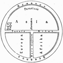
Thursday, January 7, 2010
World Map 15th Century
Description: T-O world map based on the medieval world view of the Spanish Archbishop Isidore of Seville (c. 560-636), published between 1459-1463 in La Fleur des Histoires by Jean Mansel.
 (Highest res.: jpg, 600 x 819 pixel, 75 dpi, file size: 121 KB)
 (Highest res.: jpg, 600 x 819 pixel, 75 dpi, file size: 121 KB)
Tuesday, December 8, 2009
World Map 18th Century
Description: World map from the French cartographer Nicolas de Fer, published in 1722.
 (Highest res.: jpg, 2048 x 1365 pixel, 96 dpi, file size: 1 MB)
 (Highest res.: jpg, 2048 x 1365 pixel, 96 dpi, file size: 1 MB)
Sunday, November 1, 2009
World Map 15th Century
Description: World map of the German cartographer Andreas Walsperger made in 1448.
 (Highest res.: jpg, 1013 x 1024 pixel, 200 dpi, file size: 1,05 MB)
 (Highest res.: jpg, 1013 x 1024 pixel, 200 dpi, file size: 1,05 MB)
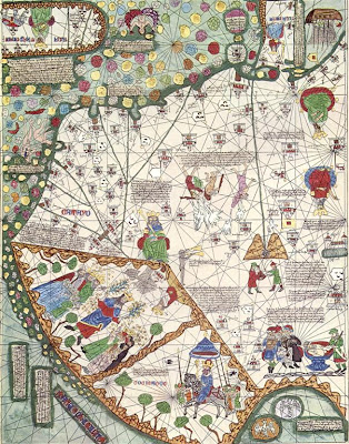
Sunday, October 25, 2009
World Map 14th Century
Description: The Catalan Atlas produced in 1375 by the Majorcan cartographers Abraham and Jehuda Cresques is the most important Catalan world map of the Middle Ages. The world map originally consisted of various leaves.
Europe
Middle East

East Asia
 (Highest res.: jpg, max. 1000 x 1000 pixel, 72-300 dpi, file sizes: 150-300 KB)
Europe

Middle East

East Asia
 (Highest res.: jpg, max. 1000 x 1000 pixel, 72-300 dpi, file sizes: 150-300 KB)
Sunday, September 20, 2009
World Map 18th Century
Description: The so-called "Zheng He map" is a Chinese world map, probably produced in 1763 at the base of Zheng He's voyages.

(Highest res.: jpg, 5274 x 3742 pixel, 475 dpi, file size: 3,38 MB)

(Highest res.: jpg, 5274 x 3742 pixel, 475 dpi, file size: 3,38 MB)
Wednesday, September 16, 2009
World Map 18th Century
Description: Engraved world map by the German cartographer Leonhard Euler first published 1753 in his school atlas "Geographischer Atlas".

(Highest res.: jpg, 2615 x 2252 pixel, 72 dpi, file size: 2,78 MB)

(Highest res.: jpg, 2615 x 2252 pixel, 72 dpi, file size: 2,78 MB)
Tuesday, September 1, 2009
World Map 15th Century
Description: The "Genoese map" is a world map from an unkown Italian cartographer made in 1457.

(Highest res.: jpg, 2592 x 1645 pixel, 96 dpi, file size: 865 KB)

(Highest res.: jpg, 2592 x 1645 pixel, 96 dpi, file size: 865 KB)
Subscribe to:
Posts (Atom)


