(Highest res.: jpg, 2048 x 1365 pixel, 96 dpi, file size: 1 MB)
Tuesday, December 8, 2009
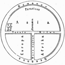
World Map 18th Century
Description: World map from the French cartographer Nicolas de Fer, published in 1722.
 (Highest res.: jpg, 2048 x 1365 pixel, 96 dpi, file size: 1 MB)
(Highest res.: jpg, 2048 x 1365 pixel, 96 dpi, file size: 1 MB)