(Highest res.: jpg, 1236 x 654 pixel, 72 dpi, file size: 484 KB)
Monday, May 31, 2010
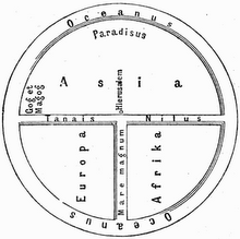
World Map 16th Century
Description: The Caverio Map (also called Caveri Map or Canerio Map) is a world map drawn by the Genoese cartographer Nicolay de Caveri, circa 1505.
 (Highest res.: jpg, 1236 x 654 pixel, 72 dpi, file size: 484 KB)
(Highest res.: jpg, 1236 x 654 pixel, 72 dpi, file size: 484 KB)