(Highest res.: jpg, 3500 x 2374 pixel, 96 dpi, file size: 2,34 MB)
Wednesday, October 26, 2011
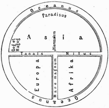
World Map 19th Century
Description: Charles Desilver's world map, published in his New Universal Atlas 1856/USA.
 (Highest res.: jpg, 3500 x 2374 pixel, 96 dpi, file size: 2,34 MB)
(Highest res.: jpg, 3500 x 2374 pixel, 96 dpi, file size: 2,34 MB)