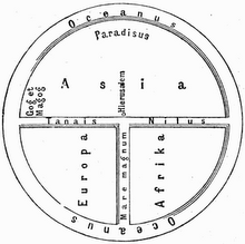
Description: The Babylonian world map, known as Imago Mundi, dated to the 6th century BCE is one of the oldest known world maps, which shows Babylon on the Euphrates, surrounded by a circular landmass with Assyria, Armenia, Ocean and islands arranged around, forming a seven-pointed star.

(Highest res.: jpg, 368 x 500 pixel, 72 dpi, file size: 187 KB)