 (Highest res.: jpg, 5000 x 2925 pixel, 96 dpi, file size: 4,59 MB)
Sunday, May 1, 2011
World Map 19th Century
Description: Japanese world map in two hemispheres dating to 1848 by Shincho Kurihara and Heibe Chojiya.
 (Highest res.: jpg, 5000 x 2925 pixel, 96 dpi, file size: 4,59 MB)
 (Highest res.: jpg, 5000 x 2925 pixel, 96 dpi, file size: 4,59 MB)
Labels:
19th century
Sunday, April 3, 2011
World Map 17th Century
Description: A New And Accurat Map Of The World published by the Belgian engraver Peter van den Keere in 1646.
 (Highest res.: jpg, 1687 x 1224 pixel, 144 dpi, file size: 1,88 MB)
 (Highest res.: jpg, 1687 x 1224 pixel, 144 dpi, file size: 1,88 MB)
Labels:
17th century
Saturday, March 12, 2011
World Map 18th Century
Description: World map created by the German or Dutch cartographer Herman(n) Moll in 1709.
 (Highest res.: png, 1423 x 826 pixel, 72 dpi, file size: 2,59 MB)
 (Highest res.: png, 1423 x 826 pixel, 72 dpi, file size: 2,59 MB)
Labels:
18th century
Saturday, February 12, 2011
World Map 19th Century
Description: Political world map illustrated by the English artist Walter Crane showing the extent of the British Empire in 1886.
 (Highest res.: jpg, 9876 x 7346 pixel, 72 dpi, file size: 20,3 MB)
 (Highest res.: jpg, 9876 x 7346 pixel, 72 dpi, file size: 20,3 MB)
Labels:
19th century
Monday, January 3, 2011
World Map 16th Century
Description: World map of the Portuguese cartographer Domingo Teixeira drawn in 1573 with the sea routes of Vasco da Gama and Hernando de Magallanes. Moreover the map shows the the meridian of Tordesillas, which devided the new discovered lands between Spain and Portugal.
 (Highest res.: jpg, 5000 x 2447 pixel, 254 dpi, file size: 2,51 MB)
 (Highest res.: jpg, 5000 x 2447 pixel, 254 dpi, file size: 2,51 MB)
Labels:
16th century
Saturday, December 11, 2010
World Map 18th Century
Description: World map (1745) from an unknown author.
 (Highest res.: jpg, 1000 x 672 pixel, 96 dpi, file size: 165 KB)
 (Highest res.: jpg, 1000 x 672 pixel, 96 dpi, file size: 165 KB)
Labels:
18th century
Saturday, November 13, 2010
World Map 11th Century
Description: "Cotton" of Anglo-Saxon world map (c. 1040) appears in a copy of a classical work on geography (British Library; Cotton MSS, Tib. B. V, folio 56.)
 (Highest res.: png, 1827 x 2256 pixel, 72 dpi, file size: 6,31 MB)
 (Highest res.: png, 1827 x 2256 pixel, 72 dpi, file size: 6,31 MB)
Labels:
11th century
Sunday, October 3, 2010
World Map 12th Century
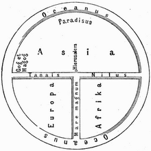
Description: World map made in 1190 by the German or Burgundian theologian Honorius Augustodunenesis, also known as Honorius of Autun.
_1190+-+Kopie+%282%29.PNG) (Highest res.: png, 1270 x 1859 pixel, 72 dpi, file size: 5,27 MB)
(Highest res.: png, 1270 x 1859 pixel, 72 dpi, file size: 5,27 MB)
_1190+-+Kopie+%282%29.PNG) (Highest res.: png, 1270 x 1859 pixel, 72 dpi, file size: 5,27 MB)
(Highest res.: png, 1270 x 1859 pixel, 72 dpi, file size: 5,27 MB)
Labels:
12th century
Thursday, September 2, 2010
World Map 16th Century
Description: World map made by the French mapmaker Guillaume Brouscon in 1543.
 (Highest res.: jpg, 8497 x 7924 pixel, 300 dpi, file size: 23,4 MB)
 (Highest res.: jpg, 8497 x 7924 pixel, 300 dpi, file size: 23,4 MB)
Labels:
16th century
Saturday, August 14, 2010
World Map 16th Century
Description: "Theatrum Orbis Terrarum" (Theatre of the World) made by the Flemish cartographer and geographer Abraham Ortelius in 1570, who is generally recognised as the creator of the first modern atlas.
 (Highest res.: jpg, 6736 x 5160 pixel, 96 dpi, file size: 32,5 MB)
 (Highest res.: jpg, 6736 x 5160 pixel, 96 dpi, file size: 32,5 MB)
Labels:
16th century
Thursday, July 8, 2010
World Map 16th Century
Description: World map made by Laurent Fries, woodcut 1522.
 (Highest res.: jpg, 3000 x 2190 pixel, 72 dpi, file size: 3,83 MB)
 (Highest res.: jpg, 3000 x 2190 pixel, 72 dpi, file size: 3,83 MB)
Labels:
16th century
Subscribe to:
Posts (Atom)


