(Highest res.: png, 1423 x 826 pixel, 72 dpi, file size: 2,59 MB)
Saturday, March 12, 2011
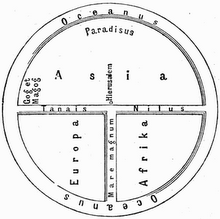
World Map 18th Century
Description: World map created by the German or Dutch cartographer Herman(n) Moll in 1709.
 (Highest res.: png, 1423 x 826 pixel, 72 dpi, file size: 2,59 MB)
(Highest res.: png, 1423 x 826 pixel, 72 dpi, file size: 2,59 MB)