(Highest res.: png, 1280 x 884 pixel, 72 dpi, file size: 2,42 MB)
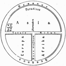
Saturday, March 24, 2012
World Map 19th Century
Description: World Map published by the Scottish engraver, printer and publisher Daniel Lizars in 1814.
 (Highest res.: png, 1280 x 884 pixel, 72 dpi, file size: 2,42 MB)
(Highest res.: png, 1280 x 884 pixel, 72 dpi, file size: 2,42 MB)
Sunday, March 4, 2012
World Map 16th Century
Description: World map published in 1589 by the Dutch cartographer and engraver Gerard de Jode.
 (Highest res.: jpg, 3080 x 2152 pixel, 96 dpi, file size: 1,46 MB)
 (Highest res.: jpg, 3080 x 2152 pixel, 96 dpi, file size: 1,46 MB)
Subscribe to:
Posts (Atom)