(Highest res.: jpg, 5500 x 4226 pixel, 96 dpi, file size: 4 MB)
Tuesday, June 29, 2010
World Map 17th Century
Description: World map made by the Dutch cartographer Joan Blaeu in 1664.
 (Highest res.: jpg, 5500 x 4226 pixel, 96 dpi, file size: 4 MB)
(Highest res.: jpg, 5500 x 4226 pixel, 96 dpi, file size: 4 MB)
Saturday, June 12, 2010
World Map 17th Century
Description: Novissima Totius Terrarum Orbis Tabula made by the Dutch timber merchant Joannes de Ram, first published in 1683.
 (Highest res.: jpg, 5500 x 4421 pixel, 96 dpi, file size: 16,1 MB)
 (Highest res.: jpg, 5500 x 4421 pixel, 96 dpi, file size: 16,1 MB)
Thursday, June 3, 2010
World Map 17th Century
Description: World map from 1666 by Peter Goos, a Dutch cartographer, engraver and bookseller.
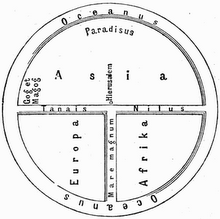
 (Highest res.: jpg, 459 x 390 pixel, 96 dpi, file size: 110 KB)
 (Highest res.: jpg, 459 x 390 pixel, 96 dpi, file size: 110 KB)
Subscribe to:
Posts (Atom)