~~~~~~~~~~~~~~~~

Tuesday, December 10, 2013

World Map 19th Century

Description: Very detailed German map of the world with various explorer routes published by C.F. Baur and Traugott Bromme in 1870.


(Highest res.: jpg, 6000 x 4557 pixel, 96 dpi, file size: 7,51 MB)

Tuesday, December 3, 2013

World Map 18th Century

Description: A new & accurate map of all the known World made by the English cartographer Emanuel Bowen in 1744. This attractive map convers the entire world as it was understood in the middle of the 18th century. The two hemispheres are surrounded by women representing four continents.


(Highest res.: jpg, 4000 x 2732 pixel, 96 dpi, file size: 3,07 MB) 

Sunday, November 24, 2013

World Map 18th Century

Description: Very detailed map of the world in a double hemisphere projection with map of the moon, the solar system and star charts created by the British mathematician and amateur astronomer Samuel Dunn dating to 1794. 


(Highest res.: jpg, 6000 x 5054 pixel, 72 dpi, file size: 27,3 MB) 

Tuesday, November 19, 2013

World Map 16th Century

Description: Orbis Typus Universalis - world map created by the German cartographer Martin Waldseemüller in 1506, first published in 1513.


(Highest res.: jpg, 2000 x 1569 pixel, 600 dpi, file size: 2,16 MB)

Friday, October 11, 2013

World Map 15th Century

Description: Woodcut world map by unknown author, published by the German book printer Lucas Brandis in 1475.


(Highest res.: jpg, 2500 x 2221 pixel, 300 dpi, file size: 3,44 MB)

Sunday, September 1, 2013

World Map 18th Century

Description: Map of the world made by the French cartographer Guillaume de L'Isle and published by the German engraver Tobias Conrad Lotter in 1775. 


(Highest res.: jpg, 4000 x 2900 pixel, 96 dpi, file size: 4,04 MB)

Saturday, August 31, 2013

World Map 17th Century

Description: World map with an unusual view of the world divided into northern and southern hemispheres centered on the poles created by the Dutch cartographer and engraver Gerard Valck in 1672.


(Highest res.: jpg, 4000 x 3051 pixel, 400 dpi, file size: 6,23 MB)

Saturday, May 25, 2013

World Map 19th Century

Description: German world map in an exceptional star projection created by Hermann Berghaus in 1880. 


(Highest res.: jpg, 3633 x 3448 pixel, 300 dpi, file size: 5,35 MB) 

Monday, May 20, 2013

World Map 18th Century

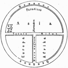
Description: Cheonhado maps (hangul: 천하도, hanja: 天下圖, literally "map of the world beneath the heavens") were made in Korea since the 17th century in response to the encounter with the geographical knowledge of the West, but based in content on traditional Asian sources and style. This map on rice paper was created by an anonymous author in the late 18th or early 19th century. 


(Highest res.: jpg, 2467 x 2400 pixel, 300 dpi, file size: 0,99 MB) 

Monday, April 1, 2013

World Map 18th Century

Description: Map of the world by the Dutch engraver Daniel Stoopendaal published in 1730.


(Highest res.: jpg, 4000 x 2765 pixel, 96 dpi, file size: 3,73 MB)

Wednesday, March 20, 2013

World Map 18th Century

Description: Nautical map of the world published by the French hydrographer and geographer J.N. Bellin in 1778 presents the entire world on a Mercator Projection based on a Paris meridian.


(Highest res.: jpg, 4000 x 2902 pixel, 96 dpi, file size: 3,66 MB)